
En esta noticia
A strengthening El Niño is expected to reshape winter weather across the United States, with a new snow map highlighting the regions that could see the biggest changes during the 2026-27 season.
The climate pattern is already becoming unusually strong. NOAA’s Climate Prediction Center said on October 8 that El Niño continues to strengthen, with a strong-to-very-strong event likely to persist through the winter. The agency also said there is a greater than 90% chance of a very strong El Niño during the Northern Hemisphere fall and winter.
That could have important consequences for snowfall. However, the impact will not be the same across the country. Some areas could receive more winter precipitation and snow, while much of the northern United States could see below-normal snowfall.

The states that could see the biggest snow changes
The latest forecasts point to a major divide between the northern and southern parts of the country.
Much of the northern U.S. is expected to lean toward warmer conditions, which could reduce the amount of precipitation that falls as snow. The pattern is particularly important across parts of the northern Rockies, northern Plains and areas around the Great Lakes.
Meanwhile, the Sierra Nevada, southern Rockies and parts of the Southwest could have a stronger opportunity for above-normal snowfall because of increased moisture combined with sufficiently cold temperatures at higher elevations.
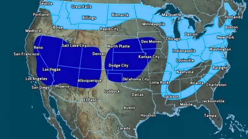
California, Utah, Arizona, New Mexico and parts of Colorado are among the areas that could benefit from the combination of a wetter storm track and mountain elevations. Recent seasonal projections have identified the central Sierra Nevada as one of the areas with a particularly strong snowfall signal.
The Southeast and parts of the central and southern United States could also experience more winter precipitation as El Niño strengthens the Pacific jet stream and shifts storm activity farther south.
Why El Niño does not automatically mean more snow
There is an important distinction between more precipitation and more snowfall.
El Niño typically favors a stronger Pacific jet stream, which can transport additional moisture into the southern United States. Historical NOAA data shows that strong El Niño winters have often produced above-average cold-season snowfall across parts of the southern half of the country, particularly in the West.
But precipitation only becomes snow when temperatures are cold enough.
That means a state can experience a wetter winter without necessarily seeing more snow. Lower elevations may receive rain during storms that produce significant snowfall in nearby mountains.
This is particularly relevant in the Northeast, where a wetter winter could bring more storms but does not guarantee a snowier season. The eventual outcome will depend on storm tracks, temperatures and the availability of cold air when individual systems arrive.

What the 2026-27 winter could look like
The current outlook suggests that the biggest shift may not be simply a nationwide increase or decrease in snowfall. Instead, El Niño could redistribute where the best chances for snow are found.
Higher elevations in the West could see more opportunities for significant snowfall, while parts of the northern United States could experience a milder and less snowy pattern.
At the same time, the central and southern United States could see a more active winter storm track. If sufficiently cold air moves into the region at the right time, some of those storms could produce substantial snow and ice.
NOAA emphasizes that even a very strong El Niño does not guarantee a specific weather outcome in every location. Seasonal outlooks describe broad probabilities over several months rather than predicting individual snowstorms.
For that reason, the map should be viewed as a seasonal guide, not a guarantee of how much snow a particular state or city will receive.
With El Niño continuing to strengthen, however, the winter of 2026-27 is shaping up to be one of the most closely watched snow seasons in years.