Mexico’s National Meteorological Service (SMN) issued a notice to the entire population due to the arrival of a “surada” that will cause winds of up to 45 mph in different parts of the Mexican territory.
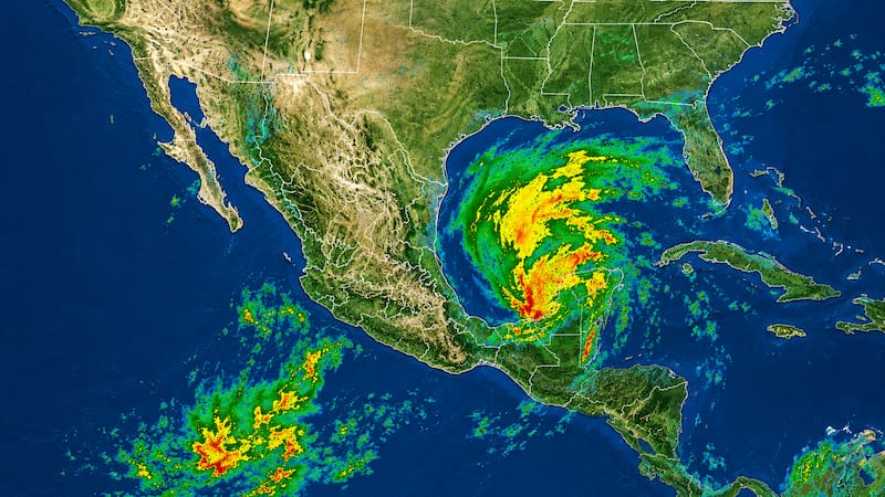
As part of this alert, the government agency responsible for disseminating weather conditions also confirmed the arrival of hail-laden thunderstorms, which will create conditions for heavy rain in different parts of the Mexican Republic.

Wind gusts will reach 45 mph in these regions
The SMN confirmed to all residents of the Mexican Republic the weather forecast starting Tuesday, June 30, when strong gusts of wind could occur throughout the day.
The government agency detailed that southerly winds (surada) will occur in several states of the country, including:
- Coahuila
- Nuevo Leon
- Tamaulipas.
Wind of 20 to 25 mph, gusts of 50 to 30 to 45 mph
- Baja California
- Sonora
- Chihuahua
- Oaxaca (Isthmus)
Wind of 15 to 20 mph with gusts of 30 to 45 mph
- Durango
- Zacatecas
- San Luis Potosi
- Chiapas
- Tabasco
- Campeche
- Yucatan.
Wind of 5 to 15 mph with gusts of 20 to 30 mph
- Baja California Sur
- Sinaloa
- Guanajuato
- Queretaro
- Hidalgo
- State of Mexico
- Mexico City
- Tlaxcala
- Puebla
- Veracruz
- Quintana Roo.
Alert for heavy rains during the next
During the forecast period, which will be in effect starting Tuesday, June 30 and for the next 96 hours, low-pressure channels, cyclonic circulations, and troughs in the middle and upper levels of the atmosphere over the interior of the national territory will combine with tropical wave No. 13 in the south and west of the country, a dry line on the northern border of Mexico, as well as atmospheric instability.
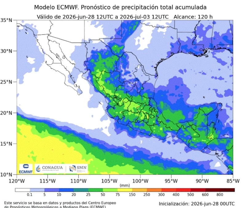
These systems will maintain the probability of showers and heavy rain accompanied by electrical discharges in most of the Mexican Republic, with heavy rain expected in specific areas that will be very heavy in states in the north, west, south, and southeast of the country; as well as intense rainfall in areas of Chihuahua and Durango.
Tuesday, June 30
- Very heavy rain with locally intense rainfall (75 to 150 mm): Jalisco (southwest).
- Heavy rain with locally very heavy rainfall (50 to 75 mm): Chihuahua (east, south, and southwest), Durango (north, west, and south), Coahuila (west), and Colima.
- Showers with locally heavy rain (25 to 50 mm): Zacatecas (west and south), Sinaloa (northeast, east, and southeast), Nayarit (north and east), Michoacan (north and east), Guerrero (center), San Luis Potosi (southwest), Aguascalientes, Guanajuato (north and center), Queretaro, Hidalgo (west), State of Mexico (north and west), Chiapas (center and east), Tabasco (east), Campeche (north and southwest), Yucatan (center and west), and Quintana Roo (south).
- Intervals of showers (5 to 25 mm): Sonora, Nuevo Leon, Tamaulipas, Mexico City, Morelos, Puebla, Tlaxcala, Veracruz, and Oaxaca.
Wednesday, July 1
- Very heavy rain with locally intense rainfall (75 to 150 mm): Veracruz (south) and Chiapas (center and west).
- Heavy rain with locally very heavy rainfall (50 to 75 mm): Chihuahua (south and southwest), Durango (northwest and north), Sinaloa (northeast and east), Puebla (southeast), Guerrero (east), Oaxaca (west, northeast, and east), Tabasco (west), and Yucatan (west and center).
- Showers with locally heavy rain (25 to 50 mm): Coahuila (northwest), Nayarit (north and east), Jalisco (north, west, and south), Colima, Michoacan (north), Zacatecas (west and south), Aguascalientes, Tamaulipas (south), San Luis Potosi (east), Guanajuato, Queretaro, Hidalgo (west), State of Mexico (north and southwest), Mexico City, Tlaxcala, Morelos, Campeche (southwest and north), and Quintana Roo (center and south).
- Intervals of showers (5 to 25 mm): Nuevo Leon.
Thursday, July 2
- Very heavy rain with locally intense rainfall (75 to 150 mm): Chihuahua (southwest).
- Heavy rain with locally very heavy rainfall (50 to 75 mm): Durango (northwest), Sinaloa (northeast and east), Guanajuato (west, center, east), Queretaro (west and south), Guerrero (east), Oaxaca (west, northeast and east), Puebla (north and southeast), Veracruz (center and south), Chiapas (center, west), and Tabasco (west).
- Showers with locally heavy rain (25 to 50 mm): Coahuila (northwest), Nayarit (north and east), Jalisco (center and east), Colima, Michoacan (north, center, and east), Zacatecas (west and south), Aguascalientes, Tamaulipas (southwest), San Luis Potosi (east), Hidalgo (west), State of Mexico (north and southwest), Mexico City, Tlaxcala, Morelos, Campeche (southwest and north), Yucatan (west and center), and Quintana Roo (center and south).
- Intervals of showers (5 to 25 mm): Nuevo Leon.
- Isolated rain (0.1 to 5 mm): Coahuila.