
En esta noticia
For decades, drivers in downtown Yonkers, New York, parked their cars above something most people could not see: a river flowing beneath the pavement.
The Saw Mill River had been hidden underground as Yonkers expanded and developed around it. What had once been an important source of power for the city’s early industries eventually disappeared beneath the urban landscape.
Then the city made an unusual decision: instead of continuing to build over the buried waterway, officials chose to bring it back into the open.
The transformation changed far more than the appearance of one downtown block. The former parking area became a public park, while the restored river created new habitat for wildlife and became part of Yonkers’ broader downtown revitalization effort.

How the Saw Mill River disappeared underground
The Saw Mill River played a major role in Yonkers’ development. Its water helped power mills as the community grew into an industrial center beginning as early as the 1650s.
But as the city became more densely developed, the river was progressively confined and covered. By the 1920s, the final section running through downtown had been placed underground beneath what became Larkin Plaza.
For years, the buried waterway was largely invisible to people passing through the area.
By the end of the 20th century, however, the surroundings had changed dramatically. The once-industrial downtown included vacant and deteriorating properties, while the river remained hidden below the surface.
The idea of restoring it had already gained support. The U.S. Army Corps of Engineers identified daylighting the river at Larkin Plaza as a potential restoration project in 1992. Later, Groundwork Yonkers and other organizations helped develop plans and gather community input for bringing the waterway back into view.
Yonkers decided to remove the parking lot
The project eventually became known as the Saw Mill River Daylighting project.
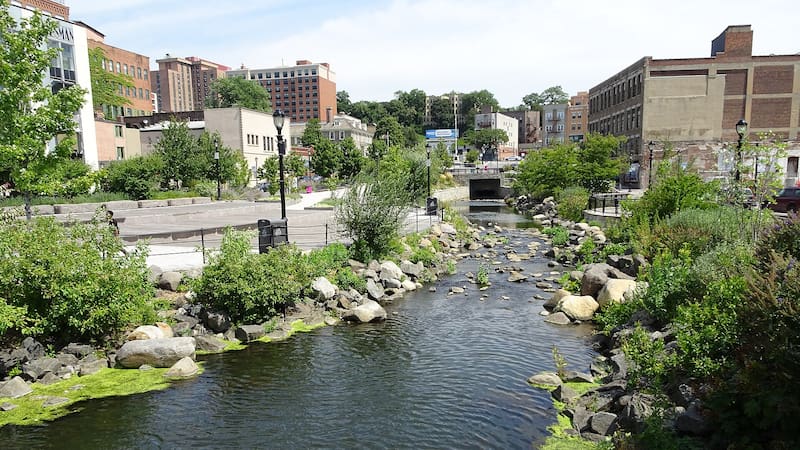
Rather than simply uncovering the old channel, engineers designed an entirely new open section of river and incorporated it into a public park. The first phase officially opened in 2012.
The project included an approximately 800-foot river diversion, pedestrian walkways, boardwalks and a bridge. The former paved landscape was transformed into a river-centered public space that connected the downtown area with the waterfront.
It was also a technically complicated undertaking.
Engineers had to account for stormwater, flooding and the river’s connection to the Hudson River. The original underground channel was not simply demolished. Instead, it remained available as an overflow route during periods of heavy rain.
Because the site had a history of industrial contamination and was treated as a brownfield, additional measures were required to protect the new river channel. Construction also involved extensive groundwater management and work around existing utilities.
A new aquatic habitat appeared surprisingly quickly
One of the most striking results came after water began flowing through the restored section.
The project created approximately 14,000 square feet of aquatic habitat, including a tidal pool and two freshwater pools. Within months, wildlife began appearing in an area that had previously been dominated by pavement and urban infrastructure.
The restored environment has supported turtles, ducks, blue crabs, black-nosed dace and the American eel. Native vegetation was also incorporated along the river, providing additional habitat and helping support insects and other organisms.
The return of wildlife gave the project an ecological dimension that went beyond simply exposing a buried river.
What had once been hidden beneath a parking lot had become a functioning urban ecosystem.

The river also changed downtown Yonkers
The restoration did not stop with environmental improvements.
The new river park became a gathering place for residents and visitors, hosting community activities, art events, music, tours and a seasonal farmers’ market. An outdoor educational area also highlights the American eel and its connection to the river ecosystem.
City officials have also linked the daylighting project to economic development in the surrounding downtown area.
In 2012, Yonkers described the next phase of the project as part of a broader effort to transform underused downtown properties and attract new commercial and residential activity. Later phases expanded the river restoration, including the opening of a 100-foot section at Mill Street in 2016 alongside nearly 20,000 square feet of new public courtyard space.
The city’s own planning documents describe the first phase as transforming a river buried beneath a parking lot for more than a century into a river-themed public park.
Why the Yonkers project remains significant
The Saw Mill River restoration demonstrates how an urban area can reconsider infrastructure that once seemed permanent.
For decades, covering the river allowed the city to use valuable downtown land for transportation and development. But the decision to reverse that approach created a different kind of value: an open waterway, wildlife habitat, public space and a new focal point for downtown.
The project also illustrates the concept of river daylighting, in which buried or enclosed waterways are brought back to the surface and integrated into the surrounding city.
In Yonkers, that strategy turned an ordinary parking area into Van der Donck Park and helped reconnect the city with a waterway that had played a role in its history long before the pavement was installed.
What was once hidden below the streets is now one of the most visible features of the downtown landscape.