En esta noticia
A Mayan city with a capacity for up to 50,000 inhabitants remained hidden beneath the jungle of Campeche, Mexico, until a doctoral student found it without leaving his computer. Luke Auld-Thomas of Tulane University was browsing page 16 of Google when he came across a LiDAR data archive containing a lost metropolis.
The find was named Valeriana and dates from between 750 and 850 A.D. Tulane researchers note that it may have functioned as a regional capital and that the discovery challenges the idea that the tropics were environments where civilizations declined.
What is the lost Mayan city the student found on Google?
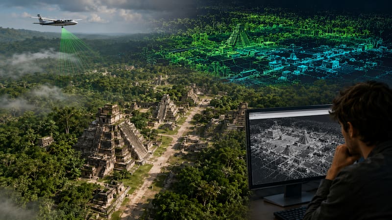
Valeriana was not found through excavations: it was detected with LiDAR, a technology that fires laser pulses from aircraft to map the terrain beneath the vegetation. By digitally removing the forest cover, researchers found pyramids, causeways, ball courts, and thousands of intact structures.

The data already existed, compiled by a Mexican environmental organization that was monitoring the ecosystem without knowing it was flying over a lost city. In total, the team identified more than 6,674 buildings. No one has visited the site in person: Valeriana remains beneath the jungle, known only through laser point maps.
Key facts about Valeriana
- Location: Campeche state, southeastern Mexico
- Period: Approximately 750–850 A.D.
- Estimated population: Between 30,000 and 50,000 inhabitants
- Urban density: Second only to Calakmul, the largest known Mayan site in Latin America
- Identified structures: More than 6,674 across the analyzed sites
Why does this discovery change what we know about Mayan civilization?
LiDAR has been rewriting ancient history for more than a decade: in 2013 it revealed urban networks in Angkor, Cambodia; in 2018 it identified more than 60,000 structures in the Guatemalan jungle. The technology makes it possible to explore in hours landscapes that would take generations to walk through.
What makes Valeriana exceptional is that the data were publicly available and no one had reviewed them for archaeological purposes. Researchers anticipate that there are more lost cities in unexplored digital archives and hope to double LiDAR coverage over the next 20 years. According to specialists at University College London, the landscape was not empty territory but one that was densely inhabited and hidden in plain sight by time.