En esta noticia
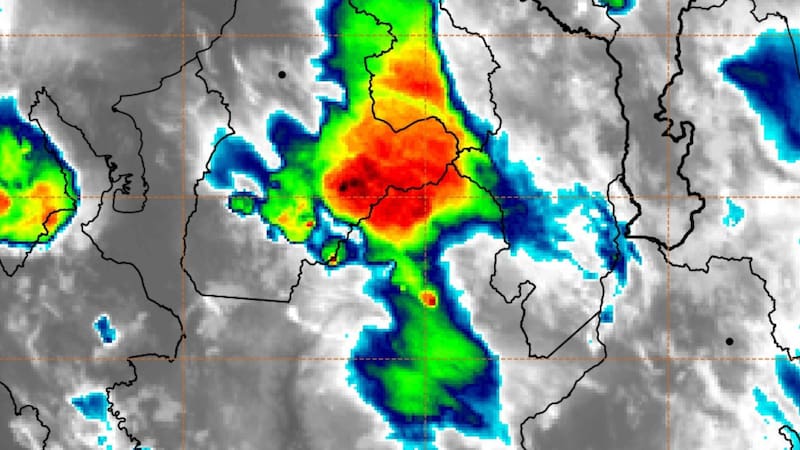
Weather forecasts anticipate a complex outlook for part of the U.S. Gulf Coast during this week. According to meteorologists, a large mass of tropical moisture will bring several consecutive days of heavy rain, storms, and flash flooding.
The areas under alert span from Texas to Alabama and, according to the forecasts, the system could remain active for much of the week and progressively increase the risk of potentially dangerous flooding in different southern states of the country.

Which areas will receive the heaviest rain over the next few days
According to AccuWeather experts, the main threat over the next few days is torrential rainfall.
Specialists point out that the most important danger is the development of flash flooding and the advice is never to cross roads covered by water.

Between Wednesday and Friday, new accumulations of between 4 and 8 inches of rain are expected across a broad stretch of the territory. Some areas could record even higher amounts within the most affected zone.
Severe weather alert for several days
Meteorologists warn that, in addition to flash flooding, the rains could cause rises in numerous river systems.
Texas rivers such as the Neches, Guadalupe, Brazos, San Antonio, Trinity, Colorado, and Nueces could experience significant increases in their flows. There is also concern about rises in rivers farther east, including the Sabine, Pearl, Tombigbee, and Alabama.

For now, forecasts keep watch on the central Gulf Coast, where rain could last for more than five consecutive days and create dangerous conditions for travelers.
The advice is to stay alert to weather conditions in case there is any major change.