
En esta noticia
The weekly AccuWeather report warns of intense storms during the first days of June in the United States. There is a warning for possible localized flooding, thunderstorms, and even hail.
The storm system will mainly impact the Great Plains and the Mississippi Valley. Wind gusts could reach 90 mph at their strongest point during the week.

The storm of the year is approaching with intense rainfall and wind gusts of up to 90 mph: weekly forecast
According to AccuWeather, more than two consecutive days of severe storms are coming to the United States, a threat that will intensify starting Tuesday and will continue until at least Thursday, with the possibility of extending for more days.
These systems are fueled by warm, moist air coming from the Gulf of Mexico, which combines with low-pressure systems and cold fronts. Among the most feared phenomena is the possibility of thunderstorms and power outages.
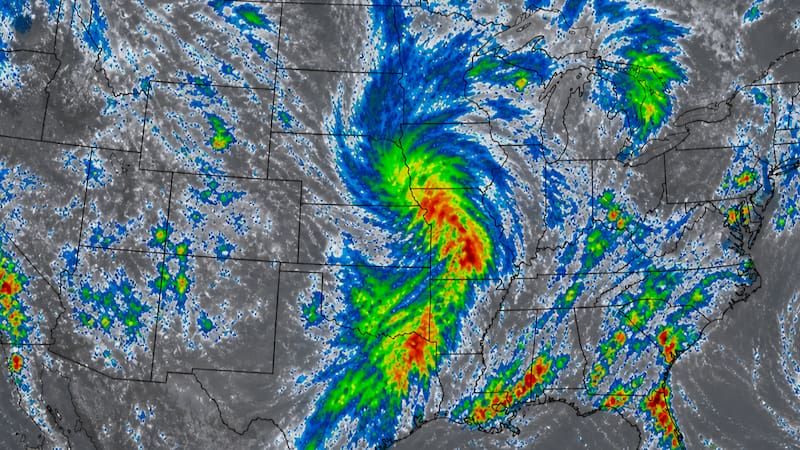
Likewise, strong wind gusts are also forecast to reach 90 mph, that is, almost 145 km/h. Additionally, large hail is also expected.
The large amount of water that will fall in such a short time could cause flooding in urban and rural areas. In turn, the storms could cause disruptions to land and air transportation.
The areas most affected by the storm of the year
The storms will begin moving on Tuesday, the day on which the following areas will be affected:
- Eastern Montana
- North Dakota
- South Dakota
- Northeastern New Mexico
- Texas Panhandle
- Southern Saskatchewan (Canada)
- Southern Manitoba (Canada)
Strong storms are also expected in parts of Florida, Georgia, and Alabama.

By Wednesday, the storm will move toward:
- Eastern North Dakota
- Central and eastern South Dakota
- Much of Minnesota
- Western Kansas
- Northeastern Colorado
The highest-risk corridor will shift eastward from the previous day. By Thursday, the storms will reach:
- Central Montana.
- Southeastern Montana.
- Southwestern North Dakota.
- Northeastern Colorado.
- Areas of the High Plains