En esta noticia
Millions of Americans could have a chance to experience a white Christmas this year, although there is still no reliable forecast for December 25. A historical snow map highlights the areas of the United States where snow on the ground has been most common during the holiday.
The National Weather Service (NWS) considers it a white Christmas when there is at least 1 inch of snow covering the ground on December 25. Historical records show that the greatest likelihood is concentrated in northern and western parts of the country, while warmer regions have traditionally had much lower probabilities.
Which states are most likely to have a white Christmas?
Historical data points to several states where the chances of finding snow on the ground during Christmas are particularly high. Among them are Idaho, Wyoming, Montana and Minnesota, along with mountainous areas of Colorado.
The northern New England region also stands out. Maine, Vermont and New Hampshire have historically experienced favorable conditions for a snowy Christmas because of their colder winter climate.
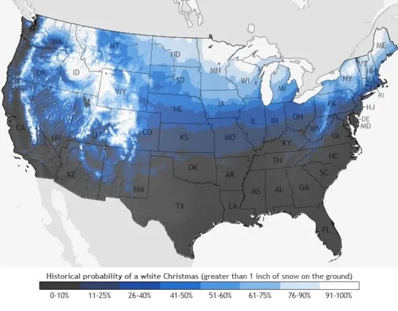
However, the map should not be read as a prediction that snow will definitely fall in those locations on December 25. Instead, it represents how frequently those areas have historically had at least one inch of snow on the ground during Christmas.
Some locations farther east also have a possibility of seeing snow during the holiday. These include portions of New York, Pennsylvania, Maryland, New Jersey and Delaware, although their historical probabilities are generally lower than those of the northern and western regions.
El Niño could affect winter conditions across the U.S.
The upcoming winter could also be influenced by El Niño, a recurring climate pattern capable of changing temperature and precipitation patterns throughout the United States.
During typical El Niño winters, December can be warmer than average across large portions of the eastern U.S. If that pattern develops, some areas could have reduced chances of maintaining snow on the ground around Christmas.
The West could experience a different pattern, particularly at higher elevations, where colder temperatures can increase the potential for snowfall. El Niño can also contribute to wetter conditions in portions of the West and South.
Northeast and western regions could see more snow
Seasonal outlooks indicate that some parts of New England, the Appalachians, the Intermountain West and the Pacific Northwest could experience periods of above-average snowfall during the winter.
The Upper Midwest could begin the season with relatively moderate temperatures before colder conditions become more common later in winter.
In the South, some areas could experience individual rain and snow events during an El Niño winter. However, the exact location, intensity and timing of those storms cannot be determined this far ahead.
What does the white Christmas map actually show?
The map is not a specific forecast for December 25, 2026. Instead, it uses historical weather data to indicate where the probability of having at least one inch of snow on the ground on Christmas Day has traditionally been highest.
A detailed forecast for Christmas will only become possible much closer to the holiday. Until then, the historical map provides a reference for identifying the parts of the country that have traditionally had the best conditions for a white Christmas.
Because winter is still months away, weather patterns can change significantly before December arrives. Therefore, the map should be viewed as a measure of historical probability, rather than confirmation that snow will fall in any particular state on Christmas Day.