En esta noticia
The National Weather Service (NWS) warned about the arrival of a “black wall” of thunderstorms that will affect different regions of the country over the next 48 hours. Official forecasts anticipate heavy rain, frequent lightning, and strong wind gusts that could reach 47 mph.
Reports from the U.S. Weather Prediction Center indicate that a broad area of instability will move in with organized thunderstorms, creating favorable conditions for severe weather and possible flash flooding.

The black wall of thunderstorms will advance over 48 hours
The frontal system will begin to intensify with thunderstorms of great vertical development, accompanied by strong wind gusts and persistent rainfall.
In addition to the strong wind, some areas could see hail and significant rainfall totals in a short time. The Weather Prediction Center noted that there is a risk of flash flooding in urban areas and vulnerable roads.
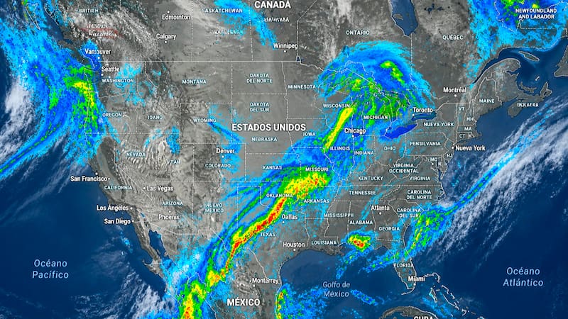
Wind gusts near 47 mph could cause reduced visibility, falling branches, and complications on roads and highways.
Which regions are at greatest risk of severe storms
The weather forecasts place the main threats over areas of the central and southern United States, although the instability area could expand into other regions as the frontal system moves forward.
Among the main phenomena forecast are the following:
- Heavy rain with significant accumulations.
- Frequent thunderstorms.
- Strong wind gusts of up to 47 mph.
- Possible isolated hail.
- Risk of flash flooding.
Specialists stressed that conditions could change quickly during the development of the storms, especially in the afternoon and evening hours, when the atmosphere reaches its highest level of instability.