En esta noticia
A strengthening El Niño is reshaping the outlook for winter 2026-27, with new maps pointing to a potentially snowier season in parts of the western United States. California, Utah, Arizona, New Mexico and southern Colorado are among the regions drawing attention, while much of the northern tier is expected to remain warmer than normal.
The Climate Prediction Center (CPC) puts the probability of a very strong El Niño at more than 90% for the Northern Hemisphere fall and winter. Its August 13 discussion also gives October through December a 69% chance of exceeding every El Niño in its record since 1950.

Which states could see more snow?
A winter forecast from OpenSnow favors California, Utah, Arizona, New Mexico and southern Colorado. The Central Sierra in California shows the clearest signal, while the southern and eastern mountains of Colorado are also included in the favored zone.
The pattern is linked to a stronger southern storm track, which can send more systems through areas high and cold enough to hold onto snow. In California, the signal is especially notable around the Central Sierra, while Utah’s mountain regions also stand out.
Colorado presents a more divided picture. The San Juan Mountains and ranges near and east of the Continental Divide are favored, while several central mountain areas sit in an equal-chances zone rather than a clear above-normal forecast.
More precipitation does not always mean more snow
One of the most important details in the outlook is that a wetter winter does not automatically mean a snowier winter. NOAA’s precipitation maps show above-normal chances across much of the southern United States and along the East Coast, but temperature determines whether that moisture arrives as snow, rain or ice.
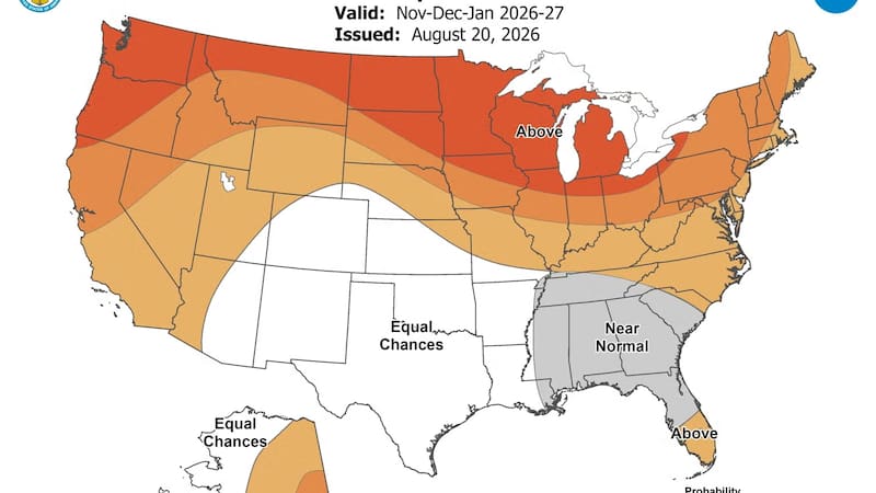
The northern tier is expected to lean warmer than normal, which can reduce snowfall even when storms bring moisture. Washington, for example, has a near-normal precipitation signal but a warmer temperature outlook, meaning some mountain precipitation could fall as rain instead of snow.
Why El Niño changes the winter pattern
El Niño occurs when ocean temperatures in the equatorial Pacific become warmer than average. That warming can alter the atmospheric circulation over North America and shift the winter storm track farther south.
During strong El Niño winters, the southern United States and parts of the West often receive more precipitation, while the northern tier tends to be warmer and less snowy. The current outlook follows that general pattern, although forecasters stress that it describes probabilities rather than guaranteed conditions.
The term “Super El Niño” is commonly used to describe an exceptionally strong event, but it is not an official NOAA category. NOAA uses the term “very strong” for an event of this magnitude.

What drivers should expect
The potential for heavier snow in the western mountains also raises questions about road conditions. In Colorado, traction requirements on the I-70 mountain corridor between Dotsero and Morrison are already in effect for the winter season. The 126-mile stretch is one of the main routes connecting Denver with the mountain areas favored by the snow outlook.
For drivers, the combination of wet snow, temperatures near freezing and overnight refreezing can create hazardous conditions. Even when a storm brings rain at lower elevations, higher mountain passes may still receive significant snowfall.
The forecast could still change
The current maps offer an early view of the season, not a final prediction for every state. NOAA notes that strong El Niño events increase the odds of typical impacts without guaranteeing them in any particular location.
For now, the strongest snow signal remains in the Southwest and southern Rockies, while much of the northern United States is expected to experience a warmer winter. The next updates from NOAA will help clarify how the pattern develops as the season approaches.