En esta noticia
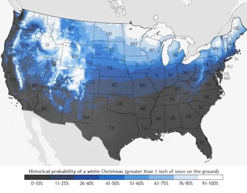
The possibility of waking up to a white Christmas could become a reality for millions of Americans this year. A new winter weather map shows which parts of the United States have historically had the highest chances of having snow on the ground on December 25.
The National Weather Service (NWS) defines a white Christmas as a Christmas morning with at least 1 inch of snow on the ground. According to the historical data reflected in the map, the highest probabilities are concentrated across several northern and western states, while other regions have significantly lower chances.
Which states have the highest chance of a white Christmas?
The areas with the greatest historical probability of having snow on the ground at Christmas include Idaho, Wyoming, Montana and Minnesota, as well as parts of Colorado.
The possibility also extends to parts of New England, particularly Maine, Vermont and New Hampshire, where winter conditions can favor snowfall during the holiday season.
The map does not mean that these states are guaranteed to have snow on December 25. Instead, it reflects the historical probability of at least one inch of snow being present on the ground on Christmas morning.
Other parts of the country could also experience a snowy Christmas, although with lower historical probabilities. Among them are areas of New York, Pennsylvania, Maryland, New Jersey and Delaware.
El Niño could influence the winter weather in the United States
The outlook for the upcoming winter is also being shaped by the expected presence of El Niño, a climate pattern that can alter temperatures and precipitation across the United States.
During traditional El Niño winters, December tends to be warmer than the historical average across much of the eastern United States, which can reduce the likelihood of a white Christmas in those areas.
At the same time, western regions at higher elevations could have better chances of seeing snow during the holiday period. The pattern can also favor wetter conditions in parts of the West and South.
More snow could fall in parts of the Northeast and West
Longer-range winter outlooks point to the possibility of above-normal snowfall in several areas, including parts of New England, the Appalachians, the Intermountain West and the Pacific Northwest.
The upper Midwest could initially experience relatively mild conditions before temperatures become colder later in the winter.
Southern states could also see episodes of rain and snow storms during an El Niño winter, although the exact conditions will depend on how the weather pattern develops closer to December.

What does the Christmas snow map actually predict?
The map should not be interpreted as a precise forecast for December 25, 2026. Its purpose is to show the historical likelihood of having at least one inch of snow on the ground on Christmas morning.
A specific forecast for Christmas Day will only become reliable much closer to the holiday. For now, the historical data suggests that the best chances for a snowy Christmas are concentrated in northern and western areas of the country, particularly in regions with colder climates and higher elevations.
With winter still several months away, weather conditions can change substantially before Christmas. Therefore, the map provides a reference for the areas traditionally most likely to experience a white Christmas, rather than a definitive prediction of snowfall for December 25.