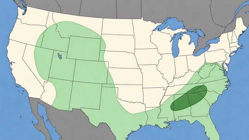

The severe weather spotlight has moved east. According to the National Weather Service’s Storm Prediction Center (SPC), a marginal risk of severe thunderstorms covers parts of the Southeast into the southern and central Appalachians on Monday, September 21, with isolated severe wind gusts possible during the afternoon.
The system driving the threat is a cold front moving southeastward across the southern and eastern United States. By afternoon, forecasters expect the boundary to stretch from northern Mississippi to western Virginia, with a moist air mass ahead of it carrying dew points in the upper 60s to mid-70s Fahrenheit from the lower Mississippi Valley into West Virginia. That moisture is expected to fuel pockets of instability, with peak buoyancy values between 2,000 and 3,000 J/kg (CAPE) forming from central Mississippi into western North Carolina as low-level convergence increases along the front.
Wind shear will stay weak, which limits the odds of organized, long-lived storm systems. Even so, forecasters say steep low-level lapse rates in the afternoon should be enough to support isolated damaging gusts from single cells or disorganized multicell clusters, with the threat largely tied to daytime heating but capable of lingering into the early evening in the areas that destabilize the most.
Local offices are already sounding the alarm. In the Carolinas, forecasters describe Monday and Tuesday as consecutive “First Alert Weather Days,” warning that scattered storms could turn severe with damaging wind gusts as the main hazard, alongside a risk of localized flooding from slow-moving cells. Meteorologists in Greenville, South Carolina, expect showers and storms to fire up mainly after 2 p.m., drifting from the mountains into the Upstate before tapering off by 10 p.m.
In the Blacksburg, Virginia forecast area, which covers north-central and northwest North Carolina and much of central and southwest Virginia, the local National Weather Service office also flagged the potential for isolated severe wind gusts Monday afternoon, along with locally heavy rainfall that could cause isolated flooding.
Rain adds a second hazard
Wind isn’t the only concern. The Weather Prediction Center (WPC) has placed a slight risk of excessive rainfall over portions of the central Appalachians and the Mid-Atlantic today, an area that includes a large stretch of West Virginia and southwestern Virginia. Forecasters attribute the threat to embedded shortwave energy interacting with a backdoor cold front and an inverted surface trough — a combination that can produce slow-moving downpours and localized flash flooding, particularly where soils are already saturated.
Tuesday: the pattern holds, but shifts slightly
The SPC’s Day 2 outlook, issued Monday, keeps the severe threat anchored in the same general region. Forecasters describe a low-amplitude mid-level trough crossing the Ohio Valley as upper-level ridging rebuilds over the Plains states, while another trough lingers over the Southwest; at the surface, a cold front will keep drifting south across the southern Appalachians and into Texas as high pressure ushers in cooler, more stable air from the north. Isolated to widely scattered storms are expected to develop along and ahead of that front Tuesday afternoon, with a couple of damaging gusts possible from wet downbursts where dew points climb into the upper 60s and low 70s and instability again reaches around 2,000 J/kg.
That rebuilding ridge is precisely why the central and southern Plains are staying out of the severe weather conversation this week. With high pressure anchored over Oklahoma, Kansas and much of Texas, the atmosphere there lacks the instability and moisture needed to support organized storms — a sharp contrast to the pattern that produced strong to severe thunderstorms, large hail and damaging wind gusts across that same region over the weekend.
What residents should watch
Meteorologists are urging residents from the Gulf Coast states up through the central Appalachians and Mid-Atlantic to monitor local forecasts through Tuesday evening, as the greatest risks — damaging straight-line winds and pockets of flash flooding — tend to develop quickly and can affect areas with little advance warning.
Beyond the Southeast, forecasters also note an uptick in shower and storm activity across the Southwest and southern Plains through Tuesday as Gulf and Pacific moisture streams into the region, though that activity is not expected to reach severe criteria.