En esta noticia
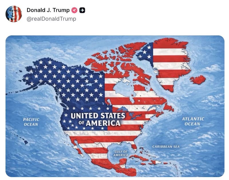
President Donald Trump has sparked a new international controversy after sharing a map on Truth Social showing a dramatically expanded United States covering Canada, Mexico, Greenland, Iceland, parts of Central America and the Caribbean.
The image shows the territories covered by the American flag, while the entire area is labeled “United States of America.” Trump posted the map without providing an explanation or saying whether it represents an actual government policy.
The post immediately drew attention because it echoes Trump’s repeated comments about expanding U.S. territory. The president has previously spoken about making Canada the 51st state and has repeatedly expressed interest in acquiring Greenland, the self-governing territory of Denmark.

Iceland summons the U.S. ambassador
Iceland was among the first countries to respond. Icelandic Foreign Minister Þorgerður Katrín Gunnarsdóttir summoned U.S. Ambassador Billy Long after the map was published.
The Icelandic Foreign Ministry told local broadcaster RÚV that the country’s position was clearly communicated to the ambassador and that the post was considered “completely inappropriate.”
The reaction is particularly notable because Iceland is a NATO member and has become increasingly concerned about U.S. rhetoric involving Greenland and the broader North Atlantic region.
The U.S. State Department and American diplomatic missions in Copenhagen, Reykjavík and Nuuk had not immediately responded to requests for comment, according to Reuters.
Denmark rejects the idea of Greenland becoming American
The map also revived tensions between Washington and Copenhagen over Greenland.
Greenland is an autonomous territory within the Kingdom of Denmark, and Danish officials have repeatedly rejected Trump’s proposals involving the island. Danish Prime Minister Mette Frederiksen reiterated that both Greenland’s government and its population have consistently said they do not want to become part of the United States.
Danish Foreign Minister Lars Løkke Rasmussen also criticized the map, describing it as inappropriate and saying it appeared to reflect an expansive vision of U.S. territory.

Why Greenland remains at the center of the dispute
Greenland has become one of the most sensitive issues in relations between the United States and Denmark because of its strategic position in the Arctic, its natural resources and its importance to military and geopolitical interests.
Trump’s latest post came as European Commission President Ursula von der Leyen visited Greenland. During the visit, the European Union announced a €200 million investment package for the territory for 2026 and 2027, highlighting Europe’s interest in strengthening its relationship with Greenland.
The timing added another layer to the controversy, although there is no evidence that the map itself was an official announcement connected to the European investment.
Does the map represent a new U.S. expansion plan?
For now, there is no official confirmation that the image represents a formal U.S. plan to annex Canada, Mexico, Greenland, Iceland or the other territories shown on the map.
Trump did not provide an explanation when he shared the image, meaning its precise purpose remains unclear. However, the post has renewed attention on his previous statements about territorial expansion and once again raised concerns among governments in the North Atlantic and beyond.